Zhejiang: region in China
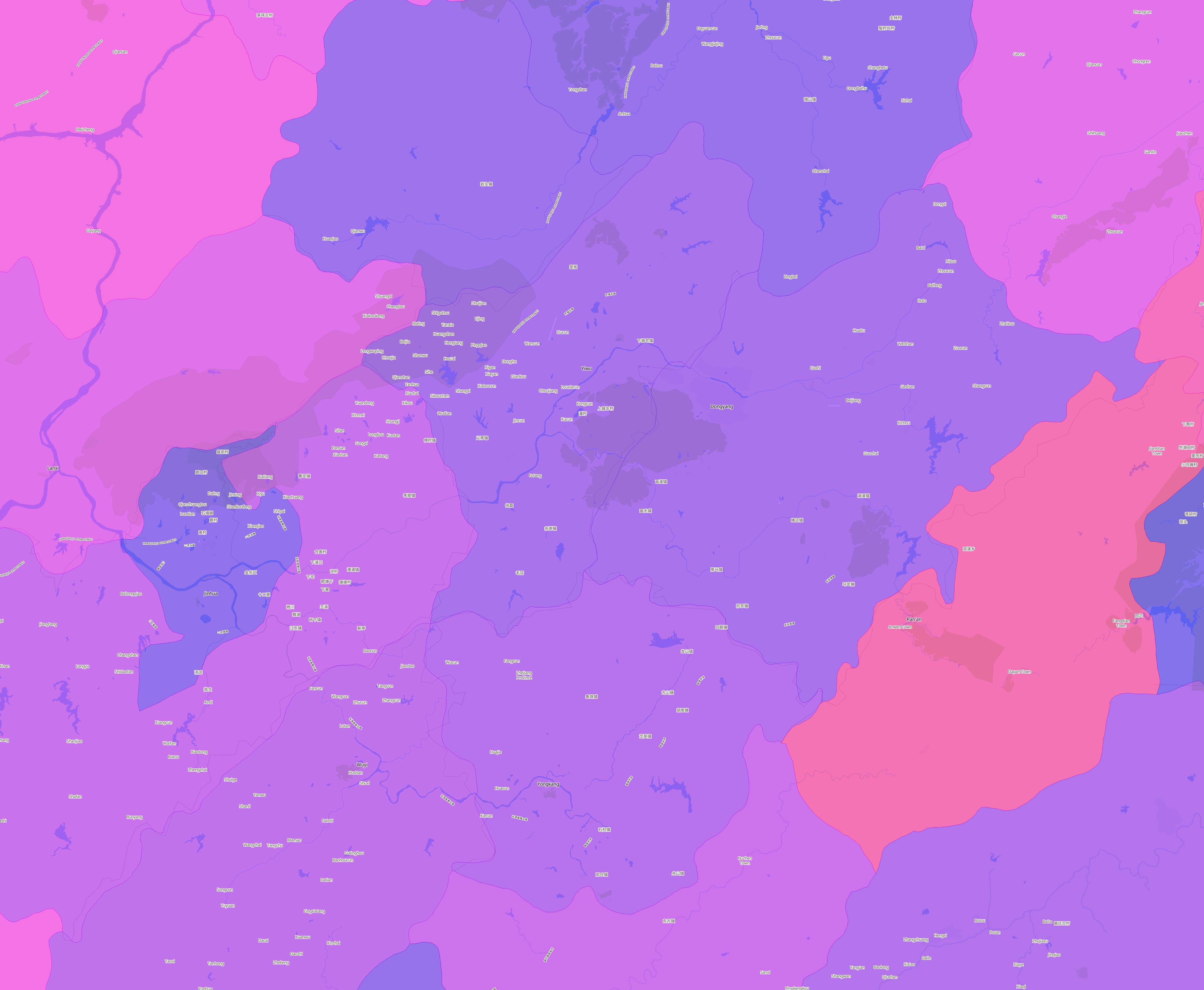
What exactly constitutes the spatial extent of the city? For these aggregations, we used the Global Human Settlement Layer Urban Center Database (GHS-UCDB) to define the boundaries of the city. These cities -- or urban centers -- cover areas that are densely populated and built-up, and so may extend beyond the spatial borders of these cities that we may be familiar with. The GHS area is shaded in blue.
View Zhejiang, China on the sprawlmap
Most recent snapshot: Taking into account the entire (i.e. aggregate) street network in Zhejiang as of 2014, the overall level of street-network sprawl is 2.93, which is in the 40th to 60th percentile of disconnectedness.
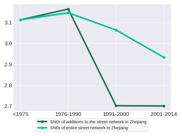
Trends in street network construction: The SNDis of street construction for the respective time periods are 3.11, 3.16, 2.7 and 2.7. Street construction in Zhejiang increased in disconnectivity initially but has since improved. The streets constructed in 1976-1990 were the most disconnected.
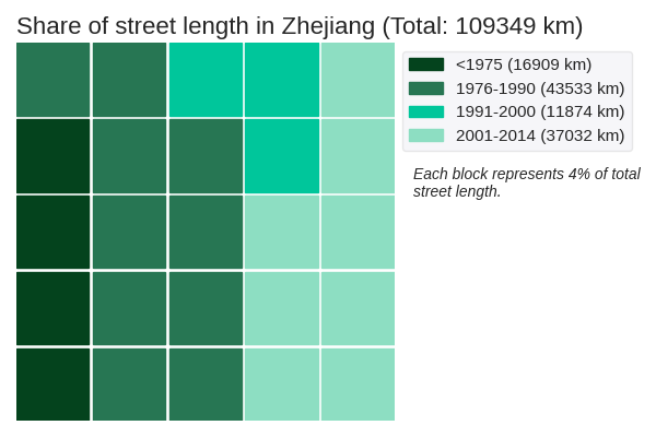
Quantity of street network construction: The street network in Zhejiang spans a total of 109349 kilometers. The period with the greatest volume of street construction was 1976-1990. These roads have an SNDi of 3.16, which is in the 40th to 60th percentile of disconnectedness.
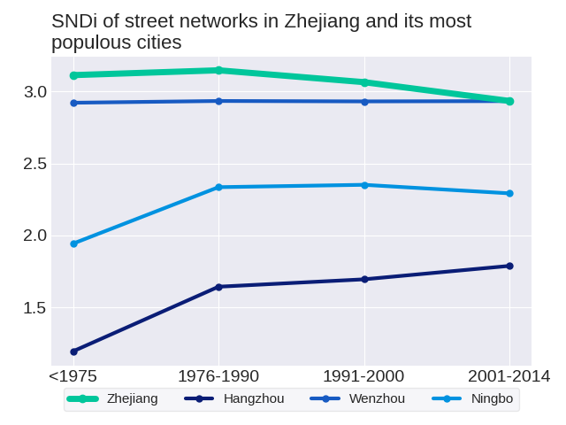
Effect on the aggregate network: New construction in each period adds to the total stock of streets, but does not change streets that have already been built. Therefore, it has a limited effect on the street network as a whole. The SNDis of the aggregate street network in the respective time periods are 3.11, 3.15, 3.06 and 2.93. The aggregate street network in Zhejiang increased in disconnectivity initially,but the trend has turned around after 1990.
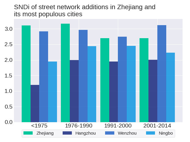
The level of street-network sprawl in new development in Zhejiang peaked in 1976-1990. To get a sense of how street development has changed in Zhejiang, we can consider three of its most populous cities: Hangzhou, Wenzhou and Ningbo. None of the most populous cities follow the same trend as the region. The level of street-network sprawl in new development in Hangzhou followed a zig-zag trend with an overall increase. The level of street-network sprawl in new development in Wenzhou followed a zig-zag trend with an overall increase. The level of street-network sprawl in new development in Ningbo peaked in 1991-2000.
How do development practices in Zhejiang fare in comparison to others in China? Most recently in 2001-2014, street construction in Zhejiang was the 25th-most disconnected out of the 34 regions in China. Its position in the ranks since 1975 has fallen; relative to other regions in China, street construction in Zhejiang has become more connected. Zhejiang ranked 16th in 1975, 18th in 1976-1990, 23rd in 1991-2000 and 25th in 2001-2014.
As of 2014, the city with the most disconnected street network in Zhejiang is Xiecun with an SNDi of 5.64, which is highly disconnected. Conversely, the most connected city is Fengqiao with an SNDi of -0.45, which is very well-connected. See trends for these cities: Fengqiao, Xiecun
The level of street-network sprawl in the aggregate network in Zhejiang peaked in 1976-1990. To get a sense of how the aggregate street network has changed in Zhejiang, we can consider three of its most populous cities: Hangzhou, Wenzhou and Ningbo. None of the most populous cities follow the same trend as the region. The level of street-network sprawl in the aggregate network in Hangzhou rose steadily. The level of street-network sprawl in the aggregate network in Wenzhou followed a zig-zag trend with an overall increase. The level of street-network sprawl in the aggregate network in Ningbo peaked in 1991-2000.
To date, Zhejiang is the 21st-most disconnected out of the 34 regions in China. Its position in the ranks since 1975 has fallen; relative to other regions in China, the street network in Zhejiang has become more connected. Zhejiang ranked 16th in 1975, 17th in 1976-1990, 18th in 1991-2000 and 21st in 2001-2014.
- Changxing
- Anji
- Chun'an
- Huzhou
- 分水镇
- Lin'an
- Deqing
- Jiangshan
- Quzhou
- 织里镇
- Jiande
- Nanxun
- 仓前街道
- 新登镇
- Hangzhou
- Tonglu
- Fuyang
- Lanxi
- 崇福镇
- Jiaxing
- 长安镇
- Jinhua
- Jiashan
- Haining
- Pujiang
- Suichang
- Zhuji
- Diankou
- 黄宅镇
- Pinghu
- Donghe
- Haiyan
- Longquan
- Yiwu
- Fengqiao
- 林埭镇
- Fotang
- Songyang
- 黄姑社区
- Wuyi
- Xiecun
- Yongkang
- Shangyu
- Cixi
- 南马镇
- Hengdian
- 芝英镇
- Yunhe
- Heyang
- Lishui
- Jinyun
- Shengzhou
- 壶镇镇
- Xinchang
- 龙山镇
- Taishun
- Ningbo
- Xikou
- XianJu
- Fenghua
- Tiantai
- Qingtian
- Wencheng
- Wenxi
- Qiaotou
- Beilun
- Ninghai
- Linhai
- Daishan
- Wenzhou
- Sanmen
- Yongjia
- Shuitou
- Zhoushan
- Cangnan
- Huangyan
- 龙港市
- Yueqing
- Pingyang
- Xiangshan
- Putuo
- 院桥镇
- Dajing
- Taizhou
- Duqiao
- Wenling
- Shipu
- Chenyu
- 新河镇
- Chumen
- Jinqing
- Yuhuan
- 松门镇
- 石塘镇