Philippines

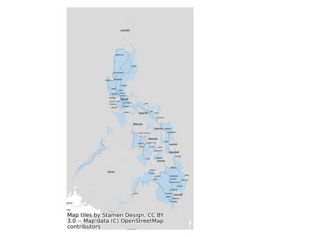
What exactly constitutes the spatial extent of the city? For these aggregations, we used the Global Human Settlement Layer Urban Center Database (GHS-UCDB) to define the boundaries of the city. These cities -- or urban centers -- cover areas that are densely populated and built-up, and so may extend beyond the spatial borders of these cities that we may be familiar with. The GHS area is shaded in blue.
View Philippines on the sprawlmap
Most recent snapshot: Taking into account the entire (i.e. aggregate) street network in Philippines as of 2014, the overall level of street-network sprawl is 5.46, which is highly disconnected.
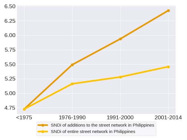
Trends in street network construction: The SNDis of street construction for the respective time periods are 4.73, 5.49, 5.94 and 6.43. In each period, new street development in Philippines steadily grows more disconnected than in the last. This increase has slowed: between 1975 and 1976-1990, SNDi rose by 0.77 points, but between 1991-2000 and 2001-2014, it rose by just 0.49.
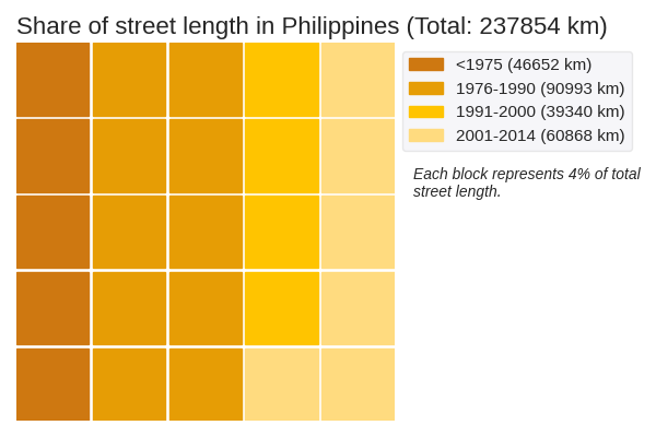
Quantity of street network construction: The street network in Philippines spans a total of 237854 kilometers. The period with the greatest volume of street construction was 1976-1990. These roads have an SNDi of 5.49, which is highly disconnected.
Effect on the aggregate network: New construction in each period adds to the total stock of streets, but does not change streets that have already been built. Therefore, it has a limited effect on the street network as a whole. The SNDis of the aggregate street network in the respective time periods are 4.73, 5.16, 5.28 and 5.46. Overall, the SNDi of the aggregate street network has risen: the street network in Philippines has become more disconnected. This increase has slowed: between 1975 and 1976-1990, SNDi rose by 0.44 points, but between 1991-2000 and 2001-2014, it rose by just 0.18.
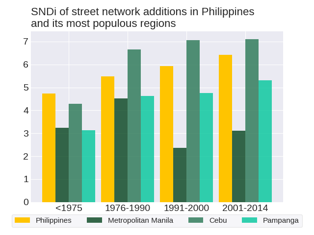
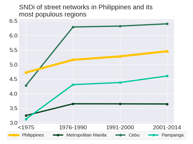
The level of street-network sprawl in new development in Philippines rose steadily. To get a sense of how street development has changed in Philippines, we can consider three of its most populous regions: Metropolitan Manila, Cebu and Pampanga. Out of the three regions, Metropolitan Manila does not follow the same trend as the country. The level of street-network sprawl in new development in Metropolitan Manila followed a zig-zag trend with an overall decrease.
How do development practices in Philippines fare in comparison to others in the world? Most recently in 2001-2014, street construction in Philippines was the 17th-most disconnected out of the 155 countries in the world. Its position in the ranks since 1975 has not changed. Philippines ranked 17th in 1975, 16th in 1976-1990, 24th in 1991-2000 and 17th in 2001-2014.
The largest city in Philippines is Quezon City [Manila], with a population of 21691100 people. Taking into account the entire (i.e. aggregate) street network in Quezon City [Manila] as of 2014, the overall level of street-network sprawl is 4.54, which is highly disconnected. The level of street-network sprawl in new development in Quezon City [Manila] followed a zig-zag trend with an overall increase.
As of 2014, the city with the most disconnected street network in Philippines is Baguio with an SNDi of 7.58, which is highly disconnected. Conversely, the most connected city is Laoag with an SNDi of -0.06, which is very well-connected. See trends for these cities: Laoag, Baguio
The level of street-network sprawl in the aggregate network in Philippines rose steadily. To get a sense of how the aggregate street network has changed in Philippines, we can consider three of its most populous regions: Metropolitan Manila, Cebu and Pampanga. Out of the three regions, Metropolitan Manila does not follow the same trend as the country. The level of street-network sprawl in the aggregate network in Metropolitan Manila peaked in 1976-1990.
To date, Philippines is the 13th-most disconnected out of the 155 countries in the world. Its position in the ranks since 1975 has risen; relative to other countries in the world, the street network in Philippines has become more disconnected. Philippines ranked 17th in 1975, 14th in 1976-1990, 15th in 1991-2000 and 13th in 2001-2014.
The largest city in Philippines is Quezon City [Manila], with a population of 21691100 people. Taking into account the entire (i.e. aggregate) street network in Quezon City [Manila] as of 2014, the overall level of street-network sprawl is 4.54, which is highly disconnected. The level of street-network sprawl in the aggregate network in Quezon City [Manila] rose steadily.
- Ilocos Norte
- Ilocos Sur
- La Union
- Pangasinan
- Benguet
- Palawan
- Zambales
- Tarlac
- Pampanga
- Bataan
- Nueva Vizcaya
- Nueva Ecija
- Cagayan
- Bulacan
- Metropolitan Manila
- Isabela
- Batangas
- Cavite
- Rizal
- Laguna
- Oriental Mindoro
- Quezon
- Sulu
- Camarines Norte
- Aklan
- Camarines Sur
- Iloilo
- Capiz
- Zamboanga del Sur
- Basilan
- Negros Occidental
- Albay
- Masbate
- Sorsogon
- Negros Oriental
- Cebu
- Zamboanga del Norte
- Bohol
- Samar
- Misamis Occidental
- Leyte
- Lanao del Norte
- Lanao del Sur
- Maguindanao
- Misamis Oriental
- Surigao del Norte
- South Cotabato
- Bukidnon
- Agusan del Norte
- Davao del Sur
- Davao del Norte