Tumbes: region in Ecuador
View Tumbes, Ecuador on the sprawlmap
Most recent snapshot: Taking into account the entire (i.e. aggregate) street network in Tumbes as of 2014, the overall level of street-network sprawl is 2.0, which is relatively well-connected.
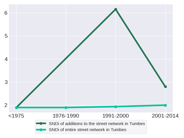
Trends in street network construction: The SNDis of street construction for the respective time periods are 1.9, nan, 6.15 and 2.8. Data was not available in 1976-1990.
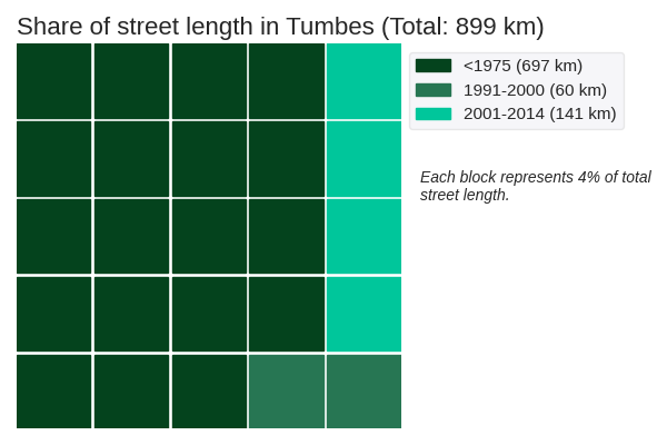
Quantity of street network construction: The street network in Tumbes spans a total of 899 kilometers. It is dominated by roads constructed prior to 1975. These roads have an SNDi of 1.9, which is relatively well-connected.
Effect on the aggregate network: New construction in each period adds to the total stock of streets, but does not change streets that have already been built. Therefore, it has a limited effect on the street network as a whole. The SNDis of the aggregate street network in the respective time periods are 1.9, 1.9, 1.94 and 2.0. Overall, the SNDi of the aggregate street network has risen: the street network in Tumbes has become more disconnected.
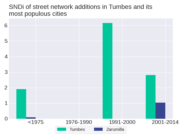
The level of street-network sprawl in new development in Tumbes followed a zig-zag trend with an overall increase. To get a sense of how street development has changed in Tumbes, we can consider one of its most populous cities: Zarumilla. None of the most populous cities follow the same trend as the region. The level of street-network sprawl in new development in Zarumilla followed a zig-zag trend with an overall increase.
How do development practices in Tumbes fare in comparison to others in Ecuador? Most recently in 2001-2014, street construction in Tumbes was the 10th-most disconnected out of the 18 regions in Ecuador. Its position in the ranks since 1975 has fallen; relative to other regions in Ecuador, street construction in Tumbes has become more connected. Tumbes ranked 10th in 1975, 3rd in 1991-2000 and 10th in 2001-2014. There was no ranking in 1976-1990 due to unavailable data.
As of 2014, the city with the most disconnected street network in Tumbes is Zarumilla with an SNDi of 0.2, which is very well-connected. Conversely, the most connected city is Zarumilla with an SNDi of 0.2, which is very well-connected. See trends for these cities: Zarumilla, Zarumilla
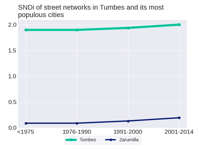
The level of street-network sprawl in the aggregate network in Tumbes rose steadily. To get a sense of how the aggregate street network has changed in Tumbes, we can consider one of its most populous cities: Zarumilla. None of the most populous cities follow the same trend as the region. The level of street-network sprawl in the aggregate network in Zarumilla rose steadily.
To date, Tumbes is the 11th-most disconnected out of the 18 regions in Ecuador. Its position in the ranks since 1975 has fallen; relative to other regions in Ecuador, the street network in Tumbes has become more connected. Tumbes ranked 10th in 1975, 10th in 1976-1990, 11th in 1991-2000 and 11th in 2001-2014.